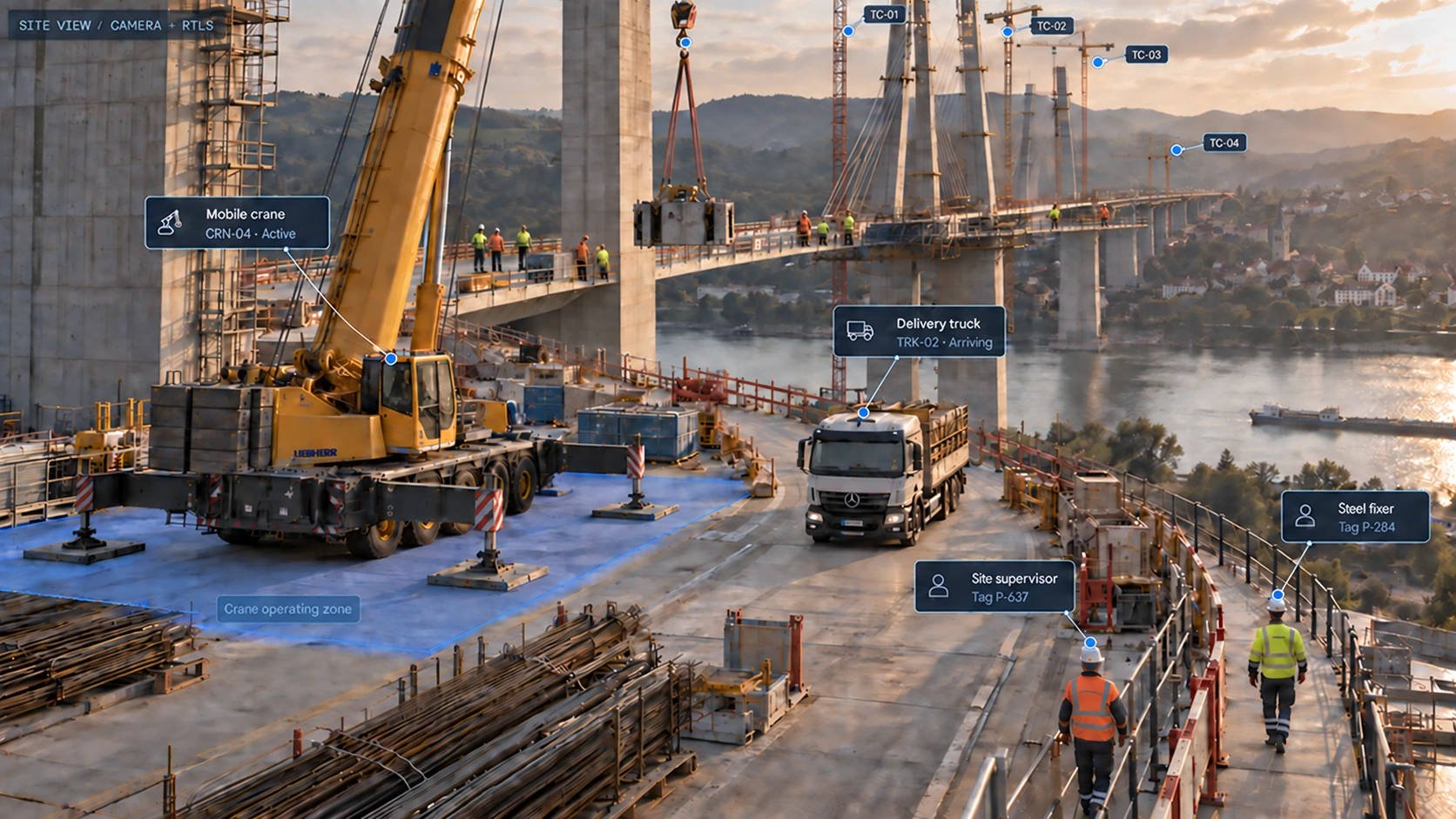
Connect sensors, camera context and project information so teams can understand what is happening, act on it and keep the record.
From the field to the decision
Understand the inputs. Trust the context.
Sensors locate the activity.
RTLS brings tagged people, machinery and assets into a shared site map. UWB uses local anchors; RTK uses satellite positioning with corrections in suitable outdoor conditions. Assignments connect tag IDs to equipment, teams and roles.
Last-seen times and missing data remain visible. Site layout, obstructions and coverage determine the installation and positioning performance.
Cameras explain the scene.
A frame helps reviewers understand access, equipment placement and conditions around an event. Link it to location history and the relevant project records.
Identities and roles come from tag assignments. They are not inferred through facial recognition. Periodic image analysis provides observations for review.
Local processing keeps the right work close.
Local proximity warnings run separately from periodic video analysis and cloud reporting. Compatible devices, warning zones and the site configuration define their operation.
Warnings alert people. They do not brake, stop or control machinery. See when a device was last connected and when its records were last updated.
Project information makes an event useful.
Relate observations to programmes, work fronts, quantities, materials and responsibilities. Mobile reporting adds the context that sensors cannot supply.
Recommendations retain source references, assumptions and revisions. The responsible person reviews consequential actions before approval.
Two sources, one view. The camera supplies the scene. RTLS supplies tag positions; equipment IDs, badges and roles come from assignments. Roles are not inferred from appearance or facial recognition.
Alignment matters. Overlay alignment requires camera calibration, a common coordinate system and timestamp alignment. RTLS positions must match the frame time; newer positions must not be presented as if captured in an older image.
01 / VISIBLE IN THE FRAME
Materials and equipment share the access area.
Steel lies beside the road; the crane’s outriggers are deployed nearby. The image alone does not establish the remaining clear width.
Source: camera 04 · frame
02 / ADDED PROJECT CONTEXT
A steel delivery is planned for tomorrow.
The delivery plan reserves crane access from 13:00–16:00. That schedule comes from the document, not from the photograph.
Source: delivery plan v3 · 17 Sep
03 / PROPOSED NEXT STEP
Check clearance before confirming the slot.
Ask the site manager to verify access width and the unloading area. The procurement lead can then review the delivery window.
Status: awaiting human review
What still needs confirmation
Scale, clearance, current site conditions and supplier availability. A single frame cannot prove waiting time, equipment utilisation or movement.
Existing construction systems
Start with the workflow. Agree the connection.
Documents and structured records
Bring reports, planning files, material registers and asset records together around your work fronts. Keep the source and latest revision clear as information moves between teams.
Project and planning platforms
Connect site information with your project and planning systems. We’ll define the right integration around your workflow, whether your team uses Procore, Autodesk Construction Cloud, Primavera or another system.
APIs and exports
Share the records your team needs, in formats they can use. Build from useful reports to connected workflows that reduce repeated entry and keep changes visible.
Practical questions
What does a site need?
A chosen workflow, a responsible team and access to the relevant records. Location use cases also need suitable tags, site coverage and agreed installation. Document-based reporting can start from existing project information.
Who can see personnel and camera records?
Agree company, project and role permissions, retention and the purpose of each data source before deployment. Team activity provides context for work review; it is not individual productivity scoring.
What happens when connectivity drops?
Local warning operation is independent of cloud and video. Confirm device power, local coverage, buffering and synchronisation behaviour in the selected installation. Cloud-dependent views and reporting need a connection to update.
 GroundOS